1,200 kilometers of coastline. Two coasts with opposing personalities. Four of the most distinctive ecosystems on the Pacific Rim held in a single territory that RED has worked inside for sixteen years.
Baja California Sur is not a destination. It is a territory. It is also the least-compromised peninsula left on this continent — a place that holds both the last intact gray-whale calving lagoons and the largest protected marine area in Latin America, where the shoreline is still written by the economies of fishing cooperatives rather than resort development. RED has been working inside this territory since 2009, and in that time we have assembled the permits, the relationships, and the operational capacity to move inside it in a way that almost no other outfit does.
The whole point of this platform is that we do not sit on the coast. We move into the land. We work with muleteer families in the mountains. We hold captain permits with fishing cooperatives. We partner with the community stewards who actually hold the concessions that structure what can happen where. This is not a matter of access that money can buy in 2026. This is a matter of sixteen years of presence, calibration, and a refusal to over-program what we do not need to over-program.
— The RED team · La Paz · Todos Santos · San Ignacio
Baja California Sur is the product of a geologic split. Fourteen million years ago, the peninsula began to separate from mainland Mexico along what would become the Sea of Cortez. Today the result is a territory that makes almost no sense by the usual conventions — it is 1,200 kilometers of coastline with two utterly different characters. The Pacific side is cool, windswept, and exposed. The Gulf side — the Sea of Cortez — is warmer, calmer, and enclosed by the presence of Sonora across the water.
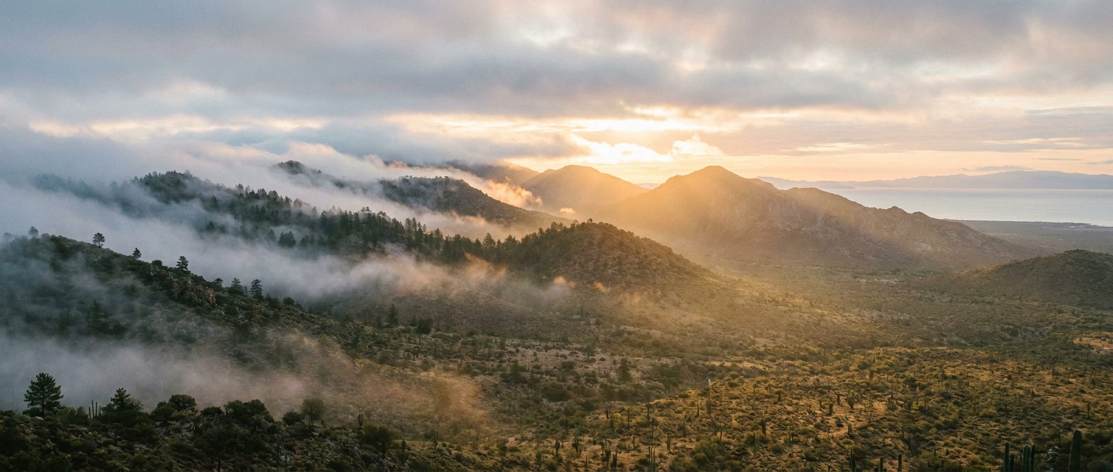
From the coast upward, the land organizes in vertical bands. In the south, you leave the beach at sea level into thorn scrub — cardón forest and cirio, the boojum tree that exists nowhere else on earth. By 400 meters, you are in coastal sage. By 800 meters, you enter oak and pine. The Sierra de la Laguna, the spine that runs the length of the peninsula, peaks at 2,090 meters with something that should not exist here at all: a cloud forest. In the southern third of the peninsula, this is the southernmost cloud forest in North America. It rains there, in a climate that should be desert.
The result is that you can climb from tropical heat to 14 degrees Celsius cooler in a day's walk. The endemism numbers bear this out: nine amphibian species found nowhere else, seventeen bird subspecies that exist in these canyons alone, a canyon treefrog that lives in exactly three ravines. The mountain families — the muleteers and ranchers who hold the permits to move inside it — have worked these canyons for five generations. They are not operators. They are stewards of a territory they have spent their lives inside.
The Sea of Cortez, the water that separates Baja from Sonora, is one of the most biologically productive bodies of water on the planet. It holds roughly 900 fish species and 32 marine mammal species in a sea that is only 150 kilometers at its widest. The nutrient upwells that fuel this richness are the product of tidal action and the shape of the basin — Cousteau called it the aquarium of the planet, and the name has held.
Every winter, 27,000 Eastern Pacific gray whales complete the longest migration of any mammal on earth — 16,000 kilometers from Alaska to the lagoons of Baja California Sur. Three of the five major gray-whale calving lagoons are here: San Ignacio, Laguna Ojo de Liebre, and Magdalena Bay. In San Ignacio, the calves approach small boats of their own volition — a behavior called los ballenatos amistosos, the friendly whales — that is not observed in any other gray-whale population in the Pacific. For reasons nobody has adequately explained, this behavior persists.
South of Los Cabos, in the community of Cabo Pulmo, a fishing cooperative and a national park ranger operation managed a recovery that is perhaps the most comprehensively documented conservation success in a temperate marine ecosystem. In 1995, the bay was nearly fished out. By 2009, biomass had increased 463 percent — the largest recovery ever documented in a protected area this small and this previously depleted (Aburto-Oropeza, 2011, PLOS ONE). You can put on a mask in that bay and see it yourself. The schools move like weather. The grouper are the size of young Labradors.
The Pericú and Guaycura peoples inhabited the southern peninsula for thousands of years before the Spanish arrived. They were maritime cultures — fishers, not agriculturalists — and the coast bore the imprint of their presence in camps, middens, and the deep knowledge of water and season. By the early 1600s, that knowledge became the backdrop for Jesuit mission expansion. The Spanish priests established a series of missions that reoriented the cultural and economic life of the peninsula toward agriculture and a different kind of settlement pattern.
By the 20th century, after the missions had been secularized and Spanish colonial governance had shifted, the economic character of the peninsula had reorganized again — this time around fishing. Coastal communities like Todos Santos, Cabo Pulmo, and San Ignacio became cooperativa villages, where families held fishing concessions and passed them down in traditional patterns. Pearl diving became part of the cultural economy. The sea remained the governing force.
What happened next is what is happening now. As resort development accelerated in Los Cabos and La Paz, the fishing economy became less viable. The cooperativas had to choose: sell the concessions and disappear into wage labor, or reinvent stewardship as their primary economic activity. Communities like Cabo Pulmo made the second choice. They stopped being fishermen and became park wardens. Multigenerational fishing families who worked these waters before protection now lead the cooperative. This model, where the fishing family becomes the conservation family, is the operative logic that RED moves within.
Cousteau called it the world's aquarium. Biologists have spent seventy years confirming the phrase was not hyperbole.— The RED studio
The southern peninsula holds some of the most comprehensively protected marine and terrestrial ecosystems on the continent. This is not by accident. The community stewardship model that emerged in the 1990s — where local fishing cooperatives transitioned to park management — created the condition for federal protection to actually mean something.
RED holds federal permits that most operators do not. We hold captain permits with fishing cooperatives at Cabo Pulmo, San Ignacio, and Espíritu Santo. We hold terrestrial permits for the Sierra de la Laguna mule traverses. These are not commercial tour licenses. They are relationships. They are concessions held by families who have been stewards of these spaces for decades.
UNESCO World Heritage Site · No-take marine protected area since 1995 · 71 km² · Managed by Cooperativa Cabo Pulmo in partnership with federal government
UNESCO Biosphere since 1994 · 112,400 hectares · Southernmost cloud forest in North America · Access via working ranches and muleteer families
UNESCO Biosphere since 1993 · 25,000 km² · Largest protected area in Latin America · Contains San Ignacio and Laguna Ojo de Liebre gray-whale lagoons
UNESCO World Heritage Site since 2005 · No-take zones since 2007 · 18-million-year-old rhyolite islands · Private captain permits with San Gabriel Cooperative
Federal marine protection · Gray-whale migration corridor · Ongoing research site · Accessible through community-based partnerships
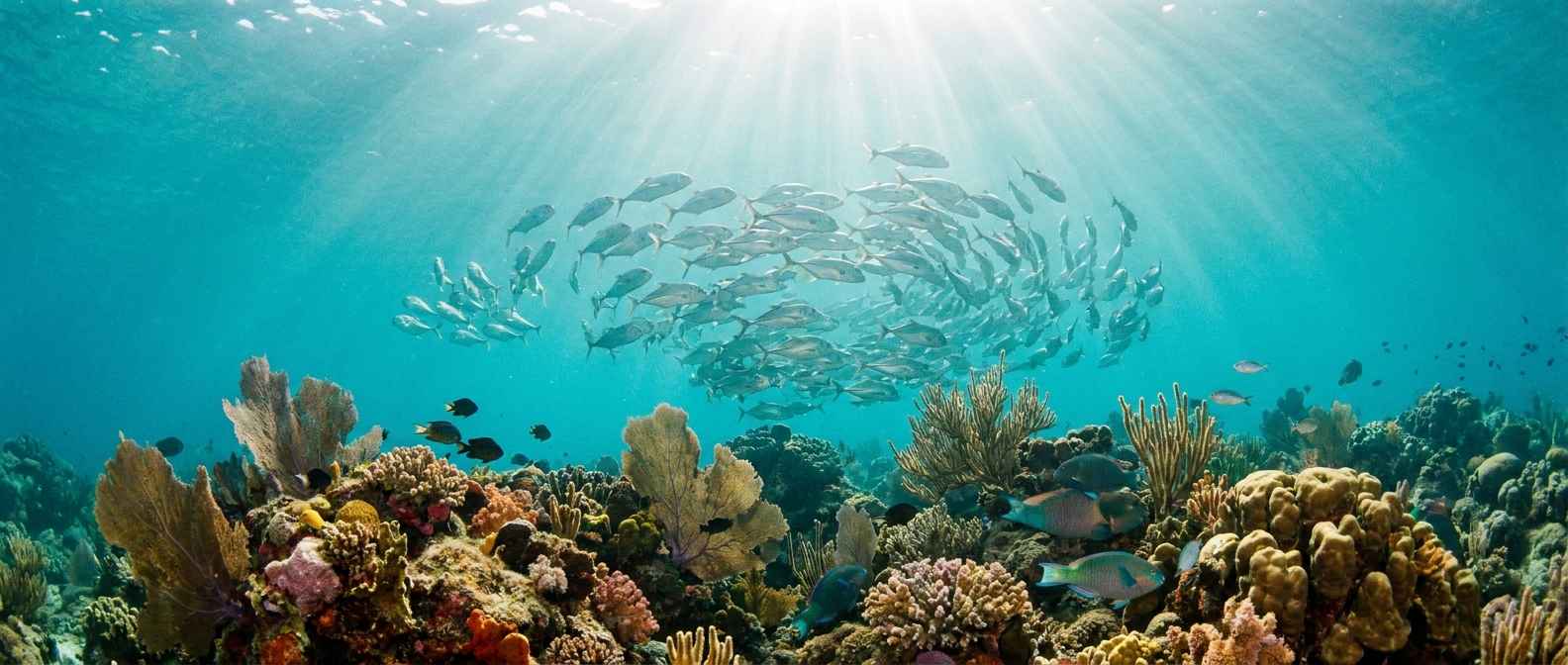
The reef that came back. A 463-percent biomass increase in a decade. Snorkel with the fish schools that peer-reviewed science says should not be this dense. Three days inside the most-recovered marine reserve on the continent, with the biologists who measured it.
Enter the reserve →In the southern third of the peninsula, mountains rise from thorn scrub to pine and oak in twelve kilometers. By 1,700 meters, you are in cloud forest — the southernmost in North America. Nine endemic amphibians. Seventeen bird subspecies. Canvas camps under the canopy.
Climb the range →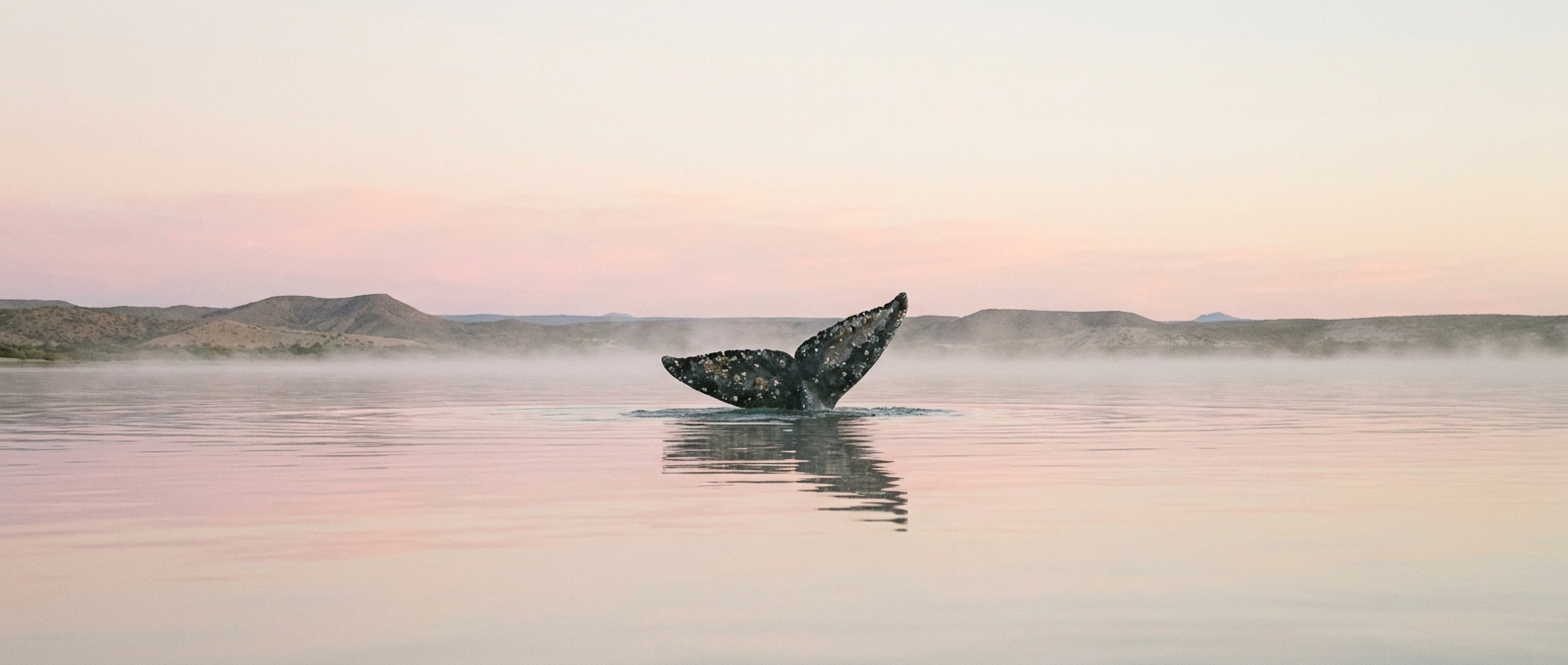
Every winter, 27,000 gray whales complete the longest migration of any mammal on earth. In San Ignacio Lagoon, the calves approach small boats on their own volition. A behavior found nowhere else in the Pacific. Two weeks during peak calving season, Mayoral family captains on the water.
Meet the migration →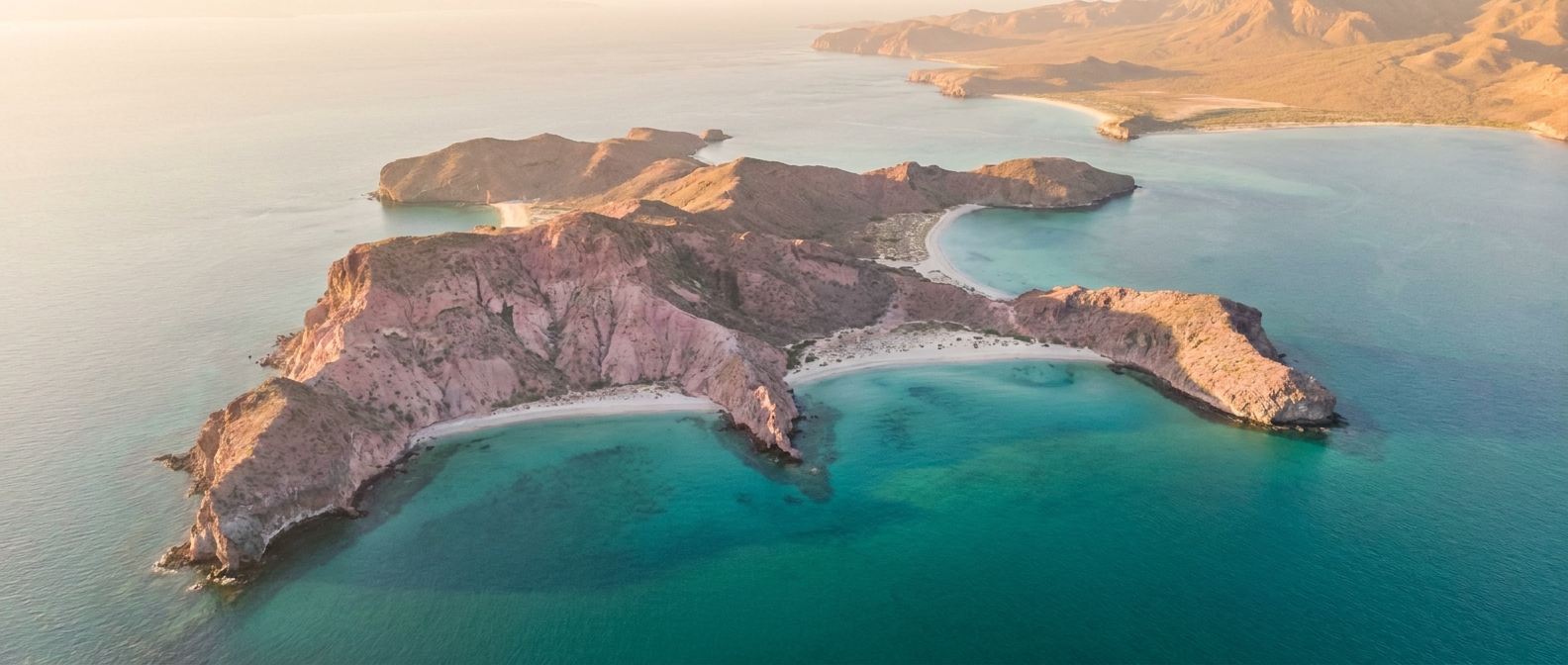
Thirty-two kilometers north of La Paz, a chain of 18-million-year-old pink rhyolite islands rises out of turquoise channels that shelve to 1,200 meters within sight of shore. Private sail charter with San Gabriel captain and a naturalist. Two or three nights at anchor in Ensenada Grande.
Sail the archipelago →Dec–Feb. Gray whales at calving lagoons. Coolest air and water temperatures. Cabo Pulmo and Espíritu Santo accessible. Mountain weather variable; Sierra traverses challenging. Peak season for whale encounters.
Mar–May. Whale season tail winds down; calves migrate north. Air temperature climbing. Reefs clearest. Mountain wildflowers and canyon flooding dependent on winter rain. Ideal window for diverse territory traverses.
Jun–Aug. Heat intense; afternoon thunderstorms frequent. Reef visibility excellent; pelagic fish biomass high. Hurricane season begins late July. Fewer travelers; highest permit availability. Requires heat tolerance and water comfort.
Sep–Oct. Hurricane risk present; weather windows narrow. Sea state calmer by early October. Marine visibility returns. Temperatures moderate. A quiet season: fewer boats, community life restored. Works for those with schedule flexibility.
Continuous operation since 2009, under one ownership.
Marine, terrestrial, and overnight — most held by fewer than four operators in BCS.
Captains, naturalists, and kitchens have been with RED for the better part of a decade.
Every itinerary. Every permit. One bus, one captain, one chef — the cap is the product.
This territory is not a destination to be consumed. It is a place that requires understanding, patience, and a willingness to move at the pace of the people who actually steward it. If you are a designer or an institution building a relationship with Baja California Sur, describe what you are trying to learn. Describe the traveler. Describe the season and the duration. We will respond with what is permitted, who is available, and what we would do.
We respond to every note within two working days from La Paz. If you have a deadline that is narrower than that, say so and we will honor it.
Describe the traveler, the territory you are interested in, and what you want to learn. We will respond with proposals, timing, and logistics within 48 hours.
For InstitutionsUniversities, conservation partners, and family offices building a multi-year relationship with the peninsula. Multi-cohort pacing, research integration, and permit stewardship.